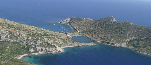
The first location of Cnidus was half-way along the Datca peninsula. The residents moved it to its present site both on the Island of Tropium and on the mainland in about 365 B.C. The island is now connected to the mainland by a low, narrow isthmus which forms two small good harbors. Its citizens grew wealthy from commerce; the peninsula was famous for its wine. It was a center of culture: two theaters and an odeum suggest many hours of entertainment.
The city also had a good medical school. Praxiteles’ most famous statue, that of the nude Aphrodite, was bought by the city after the people of Cos rejected it in favor of a more modest and less celebrated woman. The original of the Cnidus statue is still being hunted; the best copy is in the Vatican Museum.
Ctesias, the Persian historian, was a native of Cnidus as was Sostratus, the builder of the Pharos at Alexandria. The Pharos was a lighthouse considered one of the Seven Wonders of the ancient world. Eudoxus, one of the great astronomers, was also born in Cnidus. He perhaps was the head of Plato’s Academy when Aristotle joined it in Plato’s absence in 367 B.C. Eudoxus had his own school later in Cyzicus. He made a map of the stars and invented the horizontal sun dial.
There were a number of temples in the city, among them ones to Dionysus and Aphrodite. Games were celebrated there in honor of Apollo and Poseidon. The agora, the Temple of Aphrodite, the odeum, and two theaters can be seen in the ruins, thanks to recent excavations.
Cnidus was the last landfall mentioned in Asia Minor in Paul’s journey from Jerusalem to Rome. He had been put on an Egyptian ship in Myra which sailed up the coast to Cnidus; because of headwinds they took a good many days to reach it (Acts 27:7). They probably did not anchor there because of the inclement weather which continued and in fact got much worse. Instead, they went on to Fair Havens in Crete where Paul advised them to winter, but, a southerly breeze springing up, the captain put out to sea again hoping for a better harbor. The wind changed and “for days on end there was no sign of either sun or stars, a great storm was raging, and our last hopes of coming through alive began to fade” (Acts 27:20).
They had run out of food before Paul saw a vision in which he was promised safe journey for himself and all on board. After two weeks they were shipwrecked, but all were saved: some swam to land, some paddled ashore on planks or parts of the broken ship. It was the island of Malta where they landed and then spent the winter. With better weather they continued on to Rome where according to tradition Paul immeasurably strenghtened the church, wrote some of his undying letters, was tried as an incendiary in the great fire during the reign of Nero, and was executed.

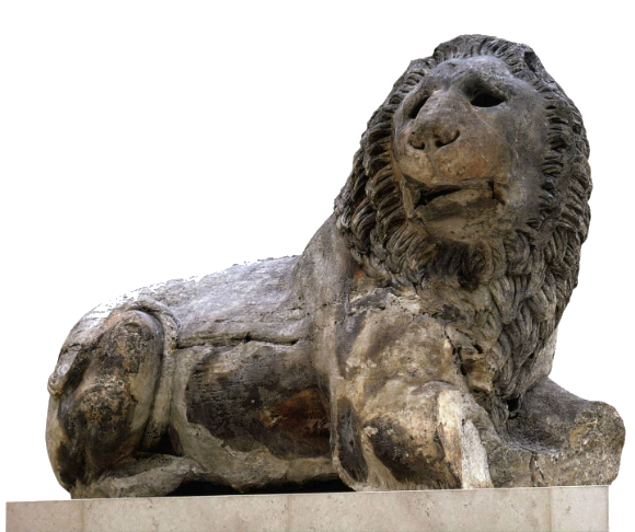
Knidos Lion “This colossal lion weighs some six tons. Made from one piece of marble, it was mounted on a base crowning a funerary monument. The monument itself was square with a circular interior chamber and a stepped-pyramid roof. It is a type of funerary monument inspired by the greater tomb of Maussollos, built about 350 BC”


We decided on a day excursion from Datca for the day and almost decided not to go to Knidos because it was so hot but we are so thankful that we made the trip. KNIDOS IS NOT TO BE MISSED. The archaeological site is quite beautiful with many columns and elaborately etched stone laid out around the site to enjoy….
This must have been a gorgeous city. We still have the view and with some imagination the ruins become buildings.
A 45-minute drive out along a winding and rutted road, through a couple of timeless villages, takes you to the site. Most of our fellow-visitors seemed to be from the various yachts anchored in the bay. It was too hot to explore entirely, but the quiet and the land/sea-scape made it well worth the trip.
Set at the end of Datca this ancient ruins site is one of the nicest to visit. You can even take a swim when it gets too hot walking around the ruins. Since it is built on a steep hill, you may have a hard time getting to all the ruins if you have any physical disabilities.
A great place to visit by sailing yacht. You can charter, bareboat or skippered from Marmaris and sail the Turkish coast
…but then we do like ancient history.
On a sailing holiday around the region, almost didn't bother to visit Knidos, but so glad we did! The guide books give no idea of its scale or state. Just incredible to stand there and imagine the way it must have been – a town of over 5000, one of the most important…
Unfortunately no guides to take you round and explain different areas of the site. There were board with information but rather spaced out so not to easy the equate with the site itself.